The past few weeks I sent off on an adventure to explore a more well-known beauty of Nepal, the Himalayas. What started as an opportunity to get out and stretch my legs resulted in a Masters in Humanities from discussions on various social issues, endless international development success stories, and an opportunity to live alongside another one of Nepal’s many castes. The trek I completed is called The Three Passes, exploring routes East and West of Mt Everest (Sagarmatha) with views of Lhotse, Ama Dablam, Cho Oyu, and countless 6000-7000m peaks, making it impossible to move faster than a snail’s pace.
I spent the first handful of days traveling with a group targeting a “trekking peak” called Imje Tse, or Island Peak. From a mountaineering perspective, it was a fairly straight forward approach. From basecamp, you can push for the summit in a single shot taking about 12 hours from bc to bc. The glaciated section is short, requiring roping in only momentarily before hitting the fixed lines. The last bit includes the use of an ascender to help you scale a 300′ ice wall before walking the summit’s knife-edge. At the top you are standing over 6000m, or 20,000ft. My highest point to date! My group was all in good health, moving rather quickly whereas I lagged on trying to trick myself into thinking it was easy and pretending there was red wine at the top. I was glad to have a friend behind me so I couldn’t hid behind a rock and pretend I had also summited. “You guys didn’t see me at the top? Hmm, strange, the altitude must be messing with you!”. They say you intake about 47% of oxygen at that elevation. Not sure who they is, but I’d believe it. Lifting a leg was hard. Maybe taking Diamox would have been a good idea…
I parted ways with my friends in Chukkung, taking a rest day before beginning the second half of my journey and them theirs. After a full day of much needed laundry, sketching, reading, and basking in the sun I was off to explore a route called the Three Passes. What a bucket worthy trip it was! The route goes over three passes above 5400m called Kongma La, Cho La, and Renjo La. With each pass comes a new set of mountain views and small villages ahead. Kongma La tends to be the hardest, however after completing Island Peak I felt like a rockstar. My body was fully acclimatized allowing me to fly past the other groups with plenty of time to spare in Lobuche. That was the only time I traveled solo for the rest of my “solo trek”.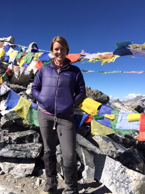
From Lobuche I traveled North to Gorak Shep and quickly moved on to Everest Basecamp and Kala Patthar. Gorak Shep was the only time on the trek I felt slightly uneasy drinking the water as it was a very distinctly brown color. Nevertheless I remained healthy with the exception of what was nicknamed “The Khumbu Cough” experienced by all trekkers due to elevation and the inhalation of yak dung from the trails and fires alike.
Overall Everest Base Camp was slightly underwhelming. Had it not been for the experience to walk in my father’s footsteps, and my Nepali led “shortcut” I might say disappointing in comparison to the journey thus far. The route from Namche Bazar straight up to EBC is the most traveled section of this hike so you simply following in line with numerous other large parties of tourists for your chance to take photos on the glacier. I can only image the masses of travelers during a season uninterrupted by earthquakes, governmental crisis and travel warnings. At EBC myself and avid mountaineering book readers carefully studied the features that have been described to us many times before setting off for Kala Patther for a view of ‘ze beast (Everest) at sunset. The friends I was traveling with at the time led us up a “shortcut” aka scenic route passing through Pumo Ri Basecamp, numerous alpine lakes, and up and down seemingly endless rolling skree hills until we reached a previously traveled trail. The remoteness of the route and view up there so worth the extra couple of hours. The wind picked up quite a bit making me thankful for my down jacket and gloves. We spent the night laughing over a Nepali card game and vowing to never follow Krishna’s short cuts again.

From Gorak Shep I took a less traveled route East running into another solo female traveler who offered me warm tea and a bite of her pancake. What a blessing as it was as it was at that the time that I realized my funds were likely to run out before making it back to the nearest ATM, about a 3 to 5 days walk depending on my desperation. I passed by the most spectacular lake on the way to Dzongla for the night eating up some time as I tried to photograph the way the blue water mixed with the dusty trail and was encapsulated with high Himalayan peaks. (Check out the picture on my Instagram!) After arriving in Dzongla, I followed an Alaskan family I met on the trail into a nearby guest house promising a warm room and the best dal bhat. Most guest houses this season have been modestly filled with plenty of room by the fire and peace to read if you like. Not this place! I silently watched hot water bottles exploding, Israelis and New Yorkers bickering, planned helicopters recuses due to rock fall, you name it! At nightfall I quickly escaped to my room, eagerly awaiting daylight to approach the second big pass.
Cho La Pass proved more difficult than the first. There was a slight scramble section at the beginning and a good amount of packed snow/ice crossing. Nothing dangerous, just made travel a bit slower. As usual, reaching the top was breath taking, both visually and physically! There were new mountains ahead and endless trails behind. After leaving the top, I found myself caught up in conversation with a few fellow travelers making me oblivious to the much discussed steep descent. After some time I plugged into the latest Beat Connection album and danced my way downhill alongside a waterfall to meet a few others for lunch. Over tea and fried noodles (Well they ate, and I had one of my snickers bars since funds were short…) I couldn’t help but laugh over the fact that I found myself sitting surrounded by the sound of waterfalls with 6 bearded dudes. That town mine as well have been named Heaven.

Crossing the glacier to reach Goyko that afternoon was an adventure to say the least. The lower part of the glaciers are unlike anything I have seen before. The glaciated ice is completely covered with mixed rock, both large moving boulders and small ball bearing style stones forming these massive waves of Earth. The route was overly marked in ranging directions making the trail navigable but difficult to discern whether you chose the correct path or not. Luckily we did and reached Goyko about two hours later.
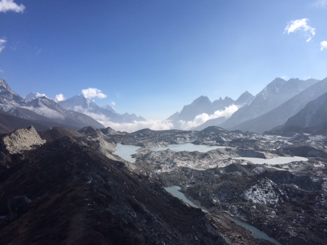
Oh Goyko, what a place. I had planned to spend some recovery time here once I arrived but didn’t realize how much time that would end up being. It’s beauty (and bakery) really suck you in! The group I was traveling with that day all ended up staying at Namaste Lodge resulting in our own little commune. Lots of cards. Some enjoyed a Nepali liquor called Roxy (sp?). We even were there to witness the installation of a satellite dish and as a result watched Mission Impossible, hemming and hawing as an international crew of mishaps each time Tom Cruise took his shirt off. While I was there I took a side trip north to Cho Oyu Basecamp, about 4 hours from Goyko. I came across a solo backpacker carrying his own tent. As he pitched it besides silent lakes beneath Cho Oyu and the surrounding peaks leading into Tibet I envied the stillness he had found and knew it was time for me to move on.

Leaving Gokyo you travel up over the third pass, Renjo La. This view spot provides the best view of Mt Everest that I had seen to date! Simply jaw dropping. Sadly down the next pass led to the end of it all, dropping a 1000m in elevation over the next day or two depending on how motivated you are to carry on to the real world.
Our next stop was Thame. Thame was a village I had originally overlooked on the map. The town was quite large in comparison to most other villages and was filled with evidence of the Buddhist influence on the region. We stayed at a guest house high on the hill overlooking the town just beneath the monastery currently home to the reincarnated Lama. While visiting the monastery, my Nepali skills came in handy when I realized the monk was describing the sickness of the lama and asked for medical help. We were ushered upstairs into the living corridors of Lama where my friend I was traveling with performed a basic examination, an encounter one would never expect to have at such a secretive place. Their home was amazing empty, with the exception of the single room that was utilized as the bed room. This room was decorated lavishly, much like a monastery, with the addition of Pringles and an iPad.
From Thame we made it back to Namche Bazar and feasted on chocolate cake before preparing for a long day back to Lukla. The place we were at draws you in with classic American hits from Rolling Stones and Tom Petty. The perfect reintroduction to society.
The last day of the trek was bittersweet. During the day we I passed by many friends I had met along the way. Yet most of the walk was done in silence, remorsefully looking back as the size of the mountains diminished. Back up at the Tara Lodge near the airport I joined a celebratory party filled with guests and their guides who had recently completed a variety of treks and peaks. One of the guides there had summited Everest 19 times and was telling stories of his adventures. On the other side of the lodge a full-fledged dance party had erupted including about 20 Germans and Nepalis. I watched for a while, then could not resist joining in. It was the perfect closing to a perfect month before returning to the crisis stricken reality of Nepal. My fingers remained crossed as we departed Lukla airport that buses were still running back to the village. Even from the airplane the lines of petrol cans were visible from the airplane as we approached the valley.
During the trek I heard about the Great Himalayan challenge, spreading across the country and exploring different sections of the range. Consider 1 of 3 sukayko!

I love your writing style and reading about your awesome adventures. I am so happy for you and wish continued good health, happiness and joy in your work. Love, UB
LikeLike
Ah thank you! Your complement made me blush from all the way over here. Love you much. Enjoy the holidays!
LikeLike
So…it sounds like you did a little bit of walking? How axing! I can’t wait to hear more about this trek. And was there any gas to get you home when you landed? Has there been any forward movement with the borders? Missing you tons but also so very excited for you!
LikeLike
Luckily there was once I stopped trying to plan and just showed up at the bus station 🙂 The crisis in Nepal however sadly continues to worsen. Let’s chat soon and I will tell yea all about it! Let me know your sched.
XOXO
LikeLike
You are amazingly inspiring! And you add light to my life from across the globe! Love you!
LikeLiked by 1 person